
WIU GIS Center Director, Students Aid in State Flooding Response
July 1, 2019
WIU GIS Center Director Chad Sperry and several WIU students developed a dashboard for state agencies to use while responding to flooding across Illinois.
[Download Print-Quality Image]
![[Download Print-Quality Image]](http://www.wiu.edu/images/news/16524/16524_8987_1.jpg)
MACOMB, IL – As state and federal officials responded to numerous flooded areas across Illinois in recent weeks, they were using information and technology generated by representatives from Western Illinois University's Geographic Information Systems (GIS) Center.
Center Director Chad Sperry spent 16 days in the Jacksonville and Springfield areas providing GIS support for the state's flood response. He was joined at various points in the trip by WIU students and alumni, including Adam Fackler, a 2019 law enforcement and justice administration major and GIS minor from Lake Zurich, IL; Jackson Walberg, a 2019 network technologies major and GIS minor from Ottawa, IL; Josh Thomas, a geography graduate student from Farmington, MO; and Ian Stearns, a junior meteorology major from Springfield, IL. In addition, GIS Center staff Keisuke Nozaki and Renee Buker supported the mission remotely by coordinating student efforts. They also spent time in Winchester, IL.
Buker ensured maps were created in a timely manner, while Nozaki even logged in from a vacation in Japan to ensure websites were up-to-date.
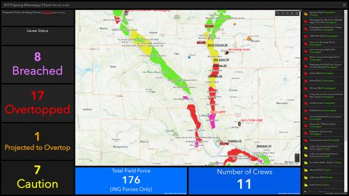
Sperry and the students designed and built a GIS dashboard, which was used by all of the participating agencies in the Incident Management Team. The dashboard allowed first responders to pull up photographs and drone video footage, much of it taken by Sperry, of all of the impacted areas, outline levee breaks and project how rising flood waters would impact a community and factors such as evacuations.
"We were assisting with management of all the resources, from National Guard troop locations and shelters to swift water rescue – it was simple things that we think 'no big deal,' but in this situation, it was a big deal" said Sperry. "The GIS was a massive coordinated effort of GIS personnel from many local, state and federal agencies - I had never been involved in such a wide spread coordinated effort, and we were fighting the flood on multiple fronts. As water began to recede in central Illinois, we began demobilizing, but the crest was reaching southern Illinois where the fight was ongoing."
The flood response encompassed the entire state of Illinois and Sperry and staff continued to support the technology remotely upon returning to Macomb.
Students rotated in and out of various command centers throughout the 16 days.
"They were excited to go, and it was a big deal for them to get the opportunity to work in that type of environment," Sperry said. "It was a real-life pressure cooker and you can't replicate that type of situation."
Walberg said the experience helped him grow personally and gain valuable emergency management experience, as well as learn about what types of mapping products are most valuable to people.
"Over the past two years, I have learned valuable GIS skills while working and studying at WIU," said Walberg. "This flood event was an excellent chance for me to show what career-specific skills I've learned, but also show people outside the world of GIS what it can do for them. Many of the people we were assisting, like National Guard troops or State Police, were not familiar with modern mapping capabilities. The ones I spoke to were very appreciative of our maps and web apps that made their work easier."
He added that the opportunity to help people in a direct way made the work satisfying.
"My previous jobs were focused on generating profit for corporations or providing entertainment, but we had the opportunity to help communities defend against the flooding," he said. "Tracking levee status and planning evacuation routes is an easily visible way that our work impacted local people for the better, and made all the long days and stress worth it to me. The experience and networking opportunities were an extra bonus, but helping people in need is the part I am most proud of."
Fackler said he became involved in emergency management during his time at WIU and attended conferences and trainings.
"All of these helped expand my knowledge outside of the classroom, but nothing could compare to being a part of a real incident and using my experience to make the operation run smoothly," he said. "It really put into perspective what I learned in my emergency management classes and from my GIS work, and being able to see the maps I created be used in a real incident gave me an overall confidence boost in my abilities and knowledge I learned here at WIU."
Fackler visited Calhoun and Scott counties to help with collecting drone footage and he said the experience helped him learn about the command structure during an emergency.
"We always talked in class about the different sections of the Incident Command Structure (ICS) and how all of the different players would have to come in to coordinate," he added. "Being on-site, and part of the organized chaos that is incident planning and response, has further cemented my interest in public safety GIS. I look forward to assisting with these operations with whatever emergency management agency I work for in the future, and I have become incredibly excited to get to work using my experience to help those affected by these disasters. Working with IEMA has further cemented the interest in disaster planning and I look forward to assisting them further when the next incident strikes - all of this is because of my experience at the GIS Center and my classes at Western Illinois University."
Sperry said the support he and the students provided to emergency responders helped keep all of the agencies "on the same page."
"GIS is really integral in these types of situations," he said. "Our students have already had job offers because of this effort and it shows the quality of our program."
The center has previously assisted with numerous other events locally and across the state, such as helping search for missing people, providing mapping capabilities for warming centers statewide during the Winter 2019 Polar Vortex, and assisting with the tornado response in Taylorville last December.
For more information about the GIS Center, visit wiu.edu/GIS.
Posted By: Jodi Pospeschil (JK-Pospeschil@wiu.edu)
Office of University Communications & Marketing
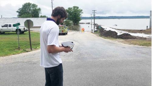
WIU Geography graduate student Josh Thomas works with information from a WIU GIS Center drone.
[Download Print-Quality Image]
![[Download Print-Quality Image]](http://www.wiu.edu/images/news/16524/16524_8988_1.jpg)
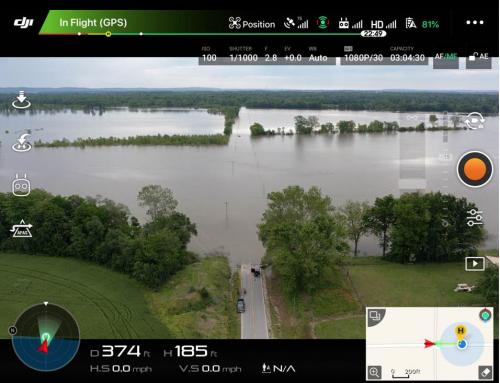
Pictured is information captured by the WIU GIS Center drone.
[Download Print-Quality Image]
![[Download Print-Quality Image]](http://www.wiu.edu/images/news/16524/16524_8989_1.jpg)
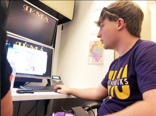
WIU sophomore meteorology student Ian Stearns works on the flooding response at a state command center.
[Download Print-Quality Image]
![[Download Print-Quality Image]](http://www.wiu.edu/images/news/16524/16524_8991_1.jpg)
Connect with us: