Earth, Atmospheric, and Geographic Information Sciences

students and faculty in GIS Center

Master of Science - GIScience and Geoenvironment

Program Highlights

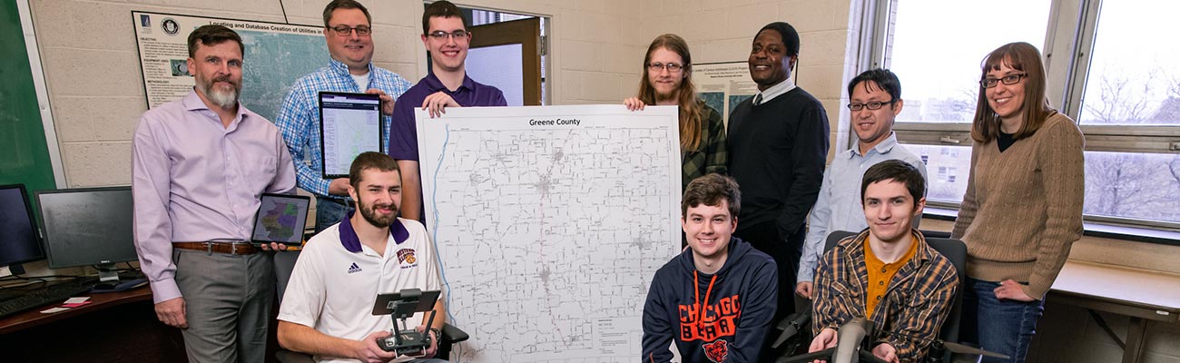
The Master of Science in GIScience and Geoenvironment focuses on training in GIScience, to deepen students’ understanding of core GIScience theories and ideas, to strengthen their ability in applying and developing GIScience methods for various environmental and social applications, to grow their skills in using and manipulating GIS tools, including its software and data, and to build up students' experiences and capabilities in designing, implementing and managing GIS projects. Progressive training is available at the introductory, intermediate, and advanced levels. The requirements are highly flexible, allowing students to arrange a program of study which serves as a basis for further graduate study or to prepare students for positions in industry, business, or government. The department has a low student-to-faculty ratio, which allows students to receive one-on-one attention and access to faculty members.

The department maintains the Meteorology Laboratory and two Geographic Information and Spatial Science laboratories. The department also houses a GIS Center, which serves as the GIS management center (spatial data creation and repository) for McDonough County, the City of Macomb and Western Illinois University.

The primary areas of faculty mentored graduate research include:

  • Planning
  • Transportation
  • Spatial analysis
  • Environmental GIS applications
  • Social GIS applications
  • Remote sensing
  • GIS visualization
  • Cartography
  • River science and geomorphology

View the Graduate Catalog for program details and course descriptions.

Integrated Baccalaureate and Master's Degrees
  • Geographic Information Science (BS) - GIScience and Geoenvironment (MS)
  • Meteorology (BS) - GIScience and Geoenvironment (MS)

The integrated degree programs provide an opportunity for our talented undergraduates to obtain both a Bachelor of Science and Master of Arts in five years. The integrated program saves students time and money.

View the Graduate Catalog for Integrated Program details.

Career Opportunities

The employment outlook for graduates with training in GIS, remote sensing and other geospatial technologies is very positive. GIScience is a strength of the department and graduate students have a consistent track record of transferring the technical and analytical skills learned in the program into successful career opportunities.

For more than 50 years, department graduates have pursued career paths in education, business and government. The growing demand for professionals with Geographic Information Science (GIScience) training has resulted in strong career opportunities for geographers with the ability to use geospatial technology to process, analyze and represent data in maps and images. Today, public and private organizations are turning to geography and GIScience to predict flood paths, analyze crop planting sites, identify locations for retail expansion and much more. The types of organizations hiring graduates of geography programs include disaster response companies, agribusinesses, transportation firms, land use planning agencies, natural resource management organizations, historic preservation firms, construction companies, real estate firms and sustainable energy companies, as well as local, regional and federal governments.

Degree Requirements

View the Graduate Catalog for program details and course descriptions.

A minimum of 32 sh of graduate credit is required for the master’s degree, 9 sh of which may be electives from outside the department. Completion of the GIScience and Geoenvironment master’s program is contingent upon the fulfillment of specific course requirements and the completion of one of three degree options:

  1. Thesis: The thesis option seeks to answer a question relevant to an area of geographic inquiry. A research proposal to be presented and the completed thesis to be defended to faculty and students.
  2. Applied Project: The applied project option is intended for students whose career aspirations are best served by gaining practical experience in the design and solution of a geographical, environmental, or planning problem and presentation of the results. A research proposal to be presented and the completed applied project to be defended to faculty and students.
  3. Professional Plan: The professional plan requires students to complete an internship and extended courses.

Admission

Applicants must meet regular admission requirements of the Western Illinois University School of Graduate Studies and have at least a cumulative GPA of 2.75 for all undergraduate coursework, or a GPA of 3.0 or higher for the last two years of undergraduate coursework, to be considered for a graduate assistantship. Students must have a working knowledge of the fundamentals of geospatial systems and geoenvironment. If deficiencies are identified, the graduate program coordinator will work with the student to address any additional coursework prior to starting the master’s program or during the first semester in the program. The master’s in GIScience and Geoenvironment is one of the integrated baccalaureate and master’s degree programs on campus.

Application

Application deadlines are clearly stated in the Graduate Catalog . In general, people seeking admission for fall semester should plan to have all application materials in by late March or early April, particularly if you are applying for a graduate assistantship.

Contact

The School of Graduate Studies processes graduate admissions materials and can answer application questions. Review package materials should be sent by email to Grad-Office@wiu.edu. This includes students who wish to update their existing package with new materials (e.g., updated transcript, new writing sample, etc., updated resume, etc.)

Graduate Assistantships

The department offers multiple graduate assistantships to accepted students, providing tuition waivers and monthly stipends in return for work under the supervision of faculty mentors. Applicants with GIS experience may have the opportunity to work in the GIS Center, where they can build strong portfolios working on real-world GIS projects. Graduate assistants are not required to teach, and all degree-seeking domestic and international students can apply. Department scholarships are also available to graduate students after one year in the program.

Graduate students with full-time assistantships are required to work 20 hours per week and be enrolled for at least 9 sh per semester. Similarly, graduate students with two-third assistantships are required to work 13 hours per week and be enrolled for at least 9 sh per semester.

An applicant must be fully admitted to the graduate program before applying for graduate assistantship. To be eligible for an assistantship, an applicant must have a GPA of 3.00 or higher, complete a GA application, and submit required documents (personal statement and letter of recommendation) before or on March 15th, in order to be considered for the upcoming academic year.

A personal statement and at least one letter of recommendation must be emailed to: eagis@wiu.edu.

Advising

After you have been accepted to the program, you should make an appointment to speak to Sociology Graduate Program Director/Advisor. Try to schedule this meeting via email during the first week of the semester. The Director will help you understand program requirements and help you develop choices of courses and options that will most help meet your goals for the degree. Throughout your time in the program, the Director is a resource to help you understand any aspect of your program. Feel free to email anytime, or to drop by the office as you have questions and concerns.

Gordon Chang

Director/Advisor

Samuel Thompson, Ph.D.
Professor of Planning