
University News
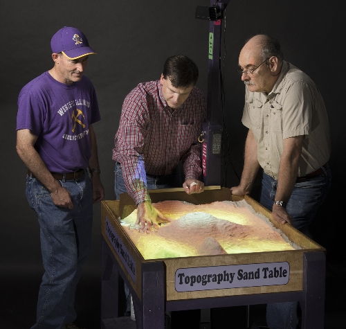
Steve Bennett, Chad Sperry, and Robert Johnson demonstrate how to use sandbox.
[Download Print-Quality Image]
![[Download Print-Quality Image]](http://www.wiu.edu/images/news/12751/12751_4686_1.jpg)
Geography and Geology Departments Build Visualization Sandbox
July 29, 2015
MACOMB, IL - -Western Illinois University's geology and geography departments have constructed a virtual augmented reality sandbox for WIU students to better study topography.
The design for the sandbox started in Spring 2015, and took about two and a half months to build. The design was inspired by University of California-Davis' W.M. Keck Center for Active Visualization in the Earth Sciences. The original goal of the sandbox was to develop a real-time integrated augmented reality system to physically create topographic models.
Associate Professor of Geology Steve Bennett found the directions for construction of the system; Geologic Museum Coordinator Robert Johnson built a moveable wooden table and sandbox and mounted the equipment, while Geographic Information Systems Center (GIS) Director Chad Sperry installed the computer software and calibrated it to work. Undergraduates and graduate students from the GIS Center also helped with the coding.
Sperry said the sandbox only cost them a few hundred dollars.
"We had an extra computer and a projector we used for free and an Xbox camera that was purchased from eBay," Sperry said. "The sandbox will be used as a recruitment tool for the geology and geography departments. It will also be used by students during classes."
The computer, Xbox camera and projector work together. The computer runs a Linux operating system and is attached through an adaptor cable to the Xbox camera. The camera senses any change in the sand surface and relays the information to the computer, which in turn maps the surface and projects the contour lines on the sand. As the sand is changed, the projected map follows almost instantly.
Individuals can use their hands to create high and low spots in the sandbox and the computer projects colored contour line (lines connecting points of equal elevation) on the sand surface in real-time. The sandbox can be used to model many different landforms, including mountains, volcanoes, valleys and streams and simulate water flow.
Many people have used the sandbox, including the science camps that visit the campus each summer. A group of high school students had an opportunity to interact with the sandbox.
Students were able to use their hands to create rivers and move the contour lines. It was a learning experience, as well as one of the "coolest things" they have seen, said the students.
Makayla Gunter, a junior in high school, from Smithen, IL, was one of the several students who attended the summer camp.
"It's really cool. The elevation is amazing. I really like seeing the water movements and different simulation. I honestly want to have one in my house. I have never seen anything like this before," said Gunter.
The sandbox will be used by both the geography and geology departments in the fall. It will offer WIU students a unique way to study landforms and maps and will help them understand the relationship between the two by using a device that simulates reality.
"The sandbox was a good collaboration for the two departments," Sperry stated.
The sandbox can be viewed in Tillman Hall. Anyone interested in learning more about the sandbox can contact Sperry at CE-Sperry@wiu.edu.
Posted By: Erika D Davis (WIUNews@wiu.edu)
Office of University Communications & Marketing
Connect with us: